연구
HOME > 연구 > 연구성과
연구성과
센서 인지 기술
라이다 기반 주행 가능 영역 검출을 위한 Argoverse-grid 데이터셋 구축 및 Grid-DATrNet 모델 개발

- Argoverse 1에서 파생된 그리드 기반 주행 가능 영역(DA) 검출 데이터셋인 Argoverse-grid(20K 이상의 프레임 및 세밀한 BEV 라벨 포함)를 구축
- 트랜스포머 기반의 최초 그리드 DA 검출 모델인 Grid-DATrNet을 제안
- Grid-DATrNet은 93.28%의 정확도와 83.28%의 F1-score로 최첨단 성능을 달성
- 글로벌 어텐션을 활용하여 CNN 기반 모델과 달리 가려진 영역 및 측정되지 않은 지역에서도 우수한 성능을 보임
SwiftPCN: 빠르고 구현 효율적이며 정확한 포인트 클라우드 복원 네트워크 개발

- 기존 포인트 클라우드 복원 네트워크(PCCN)는 뛰어난 복원 정확도를 달성했지만, 추론 속도와 메모리 소비 측면에서 한계가 있었음. 또한, 고정된 출력 해상도로 인해 입력 스캔 해상도가 다양할 경우 점 밀도 불일치가 발생할 수 있음.
- SwiftPCN은 (1) SwiftPCN-fixed와 (2) SwiftPCN-flex 두 가지 새로운 네트워크로 구성된 PCCN으로, 빠르고 정확한 복원 성능을 제공하며 다양한 출력 해상도를 지원함.
- SwiftPCN-fixed는 기존 네트워크와 비교하여 복원 정확도, 추론 지연 시간, 파라미터 수 사이의 우수한 균형을 달성함.
RTNH+: 4D 레이더 객체 탐지를 위한 전처리 및 VE 기반 네트워크 개발

- RTNH의 개선 버전인 RTNH+를 제안, 4D 레이더 측정을 활용한 객체 탐지 성능을 크게 향상.
- Two Level Processing(TLP)을 통해 동일한 4D 레이더 데이터에서 두 가지 다른 필터링 수준의 출력 데이터를 생성하여 데이터 표현력을 강화.
- The vertical encoding (VE) 알고리즘을 활용해 TLP 출력 데이터의 수직적 객체 특징을 효과적으로 인코딩.
- RTNH+는 RTNH 대비 AP(IoU=0.3, 3D)에서 10.14%, AP(IoU=0.5, 3D)에서 16.12%의 성능 향상을 달성.
정밀 측위 기술
Stepped-Frequency Binary Offset Carrier (SFBOC) 변조를 활용한 GNSS 성능 향상 기법 개발

- GNSS를 위한 새로운 변조 방식인 Stepped-Frequency Binary Offset Carrier (SFBOC)를 제안.
- SFBOC 변조는 Pseudo Random Noise (PRN) 코드 주기 내에서 subcarrier frequency를 단계적으로 변화시키며, 이를 통해 샤프한 autocorrelation function (ACF) 출력과 넓은 주파수 대역에 걸쳐 평탄한 스펙트럼 특성을 가짐.
- 기존 GNSS modulations 및 다른 time-varying subcarrier frequency (TVSF) modulations와 비교 시, SFBOC는 더 높은 거리 측정 정확도, 낮은 추적 모호성, 그리고 노이즈, 간섭, 다중 경로에 대한 높은 강건성을 보임.
BOC-FPDNet: 다중 경로 환경에서 BOC 신호의 최초 도달 경로 검출 네트워크 개발

- GNSS에서 사용되는 Binary Offset Carrier (BOC) 변조는 autocorrelation function (ACF)에 side-peaks이 존재하여 다중 경로 채널에서 위치 오차를 초래함. 이를 해결하기 위해 BOC 최초 도달 경로 검출 네트워크(BOC-FPDNet)를 제안.
-
BOC-FPDNet은 side-peaks cancellation (SC)와 다중 경로 시간 지연 추정(MDE) 두 단계로 구성됨.
- SC는 딥러닝 기반 방식으로, 추가적인 계산 부하나 노이즈 증가 없이 부측정을 제거.
- MDE는 Multi-head attention을 활용해 ACF 출력 특징을 추출하며, 양/음 샘플 검출기를 통해 시간 지연을 추정.
종단간 자율주행 기술 개발
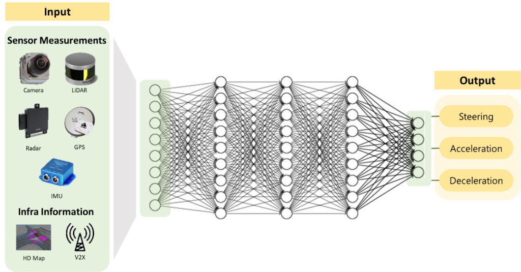
종단간 방식
- 각 모듈의 역할이 정해져 있는 모듈라 방식이 아닌 종단간 방식으로, 모든 입력 데이터를 통해 판단을 수행한다.

Simulation-to-Real (Sim2Real)
운전 정책을 개발하기 위해 실제 도로 환경에서 훈련데이터를 얻는 것은 사고확률이 높기 때문에 매우 어렵다. 이러한 데이터 수집의 한계를 극복하기 위해 시뮬레이션 환경을 활용하면서 시뮬레이션과 실제 환경간 차이(Reality Gap)을 최소화하고, 시뮬레이션에서 실제 환경으로의 효율적인 정책 전이를 달성하는 Sim2Real 기술을 연구한다.
강화학습 기반 종단간 자율주행 기술 개발
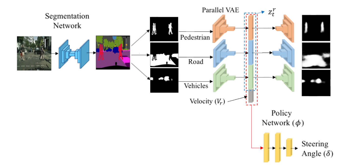
Architecture of RL-SESR(Segmented Encoder for Sim2Real)
RL-SESR Field Test
- 강화학습(RL)은 주행 환경 안에서 정의된 차량이 현재의 상태를 인식하여, 선택 가능한 행동(Throttle, Steering, etc..)들 중 보상을 최대화 하는 행동을 선택하게 하는 인공지능 학습 기법이다.
- 강화학습 기반의 종단간 자율주행은 기존의 모듈형 자율주행과 달리, 정의되지 않은 다양한 주행 상황에 스스로 대처할 수 있는 능력을 학습할 수 있다.
- 고차원의 카메라 이미지를 segmentation 한 후 VAE(Variational AutoEncoder)를 통해 저차원 공간의 정보로 압축함으로써 state generality를 높인다.
모방학습 기반 종단간 자율주행 기술 개발

Architecture of Imitation Learning-based E2E Autonomous Driving
IL-based E2E Driving Field Test
- 모방학습(IL)은 인간 운전자가 획득한 주행 데이터를 통해 그 운전 정책을 모방하도록 하는 인공지능 학습 기법이다.
- 모방학습은 데이터를 기반으로 정책을 학습하므로 경험해보지 않은 데이터에 대해서는 그 성능이 떨어질 수 밖에 없고 인간 운전자와 달리 동일한 상태에 대해 항상 일관된 행동을 출력해야 한다는 한계점이 있다.
- 이러한 모방학습의 한계를 해결하기 위해, 모방학습과 강화학습의 특성을 함께 가지는 Hybrid(RL+IL) 학습 기법을 연구하고 있다.
센서 인지 기술
LiDAR 포인트 클라우드 차선 인식 데이터셋 구축, 인공지능 기반 차선 및 객체 인식 기술
- AVE lab은 (1) 세계 최초 Lidar 차선 인식 대용량 데이터셋 (K-Lane) 을 구축하고, (2) 라이다 차선 특성을 반영한 인공지능 (Lidar Lane Detection Network utilizing Global Feature Correlator; 이하 LLDN-GFC)을 개발하여 세계 최고 수준의 차선 인식 성능을 달성한 것을 인정받아 국제 최고 Computer Vision 학회에 논문을 게재하였다.
- K-Lane은 다양한 도심지 및 고속도로 환경 (e.g., 낮, 밤, 커브, 차선 가림 등) 에서 취득한 15k 이상의 포인트 클라우드와 전방 카메라 이미지를 제공하며, 라이다 차선 인식 신경망 연구의 발전을 위해서 개발 프레임워크 (신경망 학습, 평가, 시각화, 라벨링) 를 lab Github를 통해서 제공한다.
- 또한, 본 논문에서 제안하는 LLDN-GFC는 기존 Convolutional Neural Network (CNN) 기반의 신경망 대비 6.1%의 성능 (F1-Score) 을 향상시켰으며, 특히, 다수의 차선이 가려진 경우, 10.2%의 성능을 향상시켜 다수의 차량이 밀집된 상황에서도 안전한 자율주행을 가능하게 한다.

K-Lane Dataset Examples
Labeling program
Lidar lane detection inference

Lidar lane detection framework
4D 레이다 객체 인식 기술 개발
- 4D 레이다는 자율주행용 인지 센서 중 유일하게 (1) 악천후 (e.g., 폭설, 폭우, 안개 등) 에 대해서 강건하게 동작하며, (2) 객체의 상대 속도 정보 및 주변 환경의 3D 공간 정보를 측정할 수 있는 센서이다.
- AVE lab은 세계 최초로 악천후에서의 자율주행을 위한 4D 레이다 대용량 데이터셋 및 벤치마크 (K-Radar)를 구축하였다.
- K-Radar는 (1) 세계에서 유일하게 도로 위 주요 객체에 대해서 3D 경계 박스 및 속도 정보가 정밀하게 라벨링된 35k의 4D 레이다 데이터를 제공하며, (2) 극한의 날씨 상황 (e.g., 시간 당 4cm 이상의 적설량) 과 다양한 도로 환경 (e.g., 고속도로, 국도, 도심지 등)에서 취득하였고, (3) 정밀하게 동기화된 카메라, 라이다, RTK-GPS, IMU 데이터를 함께 lab Github를 통해서 제공한다.
- 또한 AVE lab은 4D 레이다에 특화된 인코딩 기술을 개발함으로써, 세계 최고 수준의 3D 객체 인식 신경망을 달성하고 카메라, 라이다의 측정치가 사라지는 악천후 상황에서도 안정적인 3D 객체 인식이 가능함을 보였다.

4D Radar object detection inference result
Sensor measurement in heavy snow condition
4D Radar labeling process

4D Radar object detection framework
PointCloud 특징 추출 기술
- AVElab에서 개발한 PointStack은 Multi-resolution feature와 Learnable pooling을 사용하는 새로운 형태의 point cloud 특징 학습 네트워크이다.
- 아래는 AVElab에서 특징 학습 task를 위해 새롭게 설계한 PointStack의 구성요소이다.
- PointStack은 현재 SOTA 성능을 보이며, 형상 분류, 부분 의미 분할, 객체 탐지등의 매우 다양한 task에서 특징 추출 backbone으로 사용될 수 있다.
- Multi-resolution feature : Downsampling과정에서 세분화된 정보의 손실을 최소화한다.
- Learnable Pooling : 특징 풀링중 최대값이 아닌 point 특징 정보의 손실을 최소화 한다.
- PointStack은 현재 SOTA 성능을 보이며, 형상 분류, 부분 의미 분할, 객체 탐지등의 매우 다양한 task에서 특징 추출 backbone으로 사용될 수 있다.

Architecture of PointStack. As a general feature learning backbone, PointStack can be used for various tasks such as classification and segmentation

Part-segmentation visualization of ground truths (G.T.) and predictions (Pred)
저피탐 레이더(LPI RADAR) 신호 탐지 기술 개발
- 인공지능(CNN) 기술을 사용하여 Pulse waveform(PW)와 Continuous waveform(CW)을 인지 및 분류할 수 있는 기술을 개발하였다.
- 개발된 저피탐 레이더 신호 탐지 기술은 총 12개(기존 4개 및 변조 가능한 waveform 8개)의 waveform을 구분할 수 있으며 노이즈 영향에도 강건한 성능을 보였다.
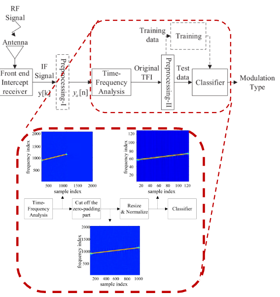
AVE lab’s LPI waveform recognition system
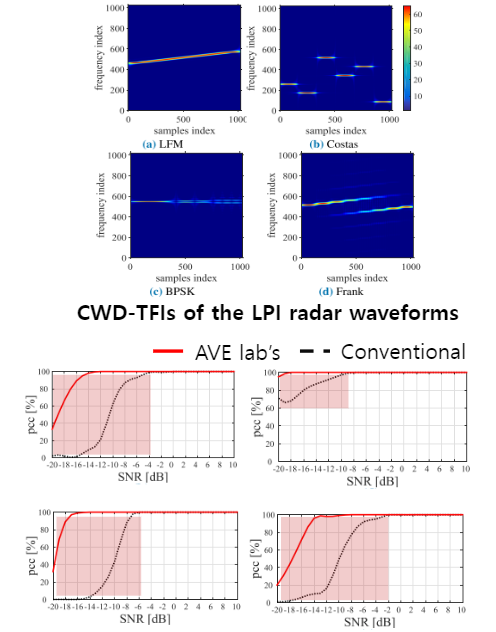
Performance Comparison
정밀 측위 기술
다중경로 완화 기술
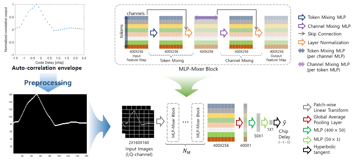
- 도시영역에서 발생하는 다중경로 채널의 영향을 완화하기 위해 인공지능 기술을 사용하여 최초 도달 GPS 신호 탐지 기술을 개발하였다.
- 기존 super-resolution기반 최초 도달 신호 탐지 기술보다 훨씬 정확한 탐지 성능과 낮은 계산량을 가진다.
- 최적의 네트워크를 선별하기 위해 다양한 인공지능 네트워크들과 벤치마킹을 수행하였고, 실제 신호로 검증하여 실질적인 연구성과를 이뤄냈다.
비가시 인공위성 검출 기술
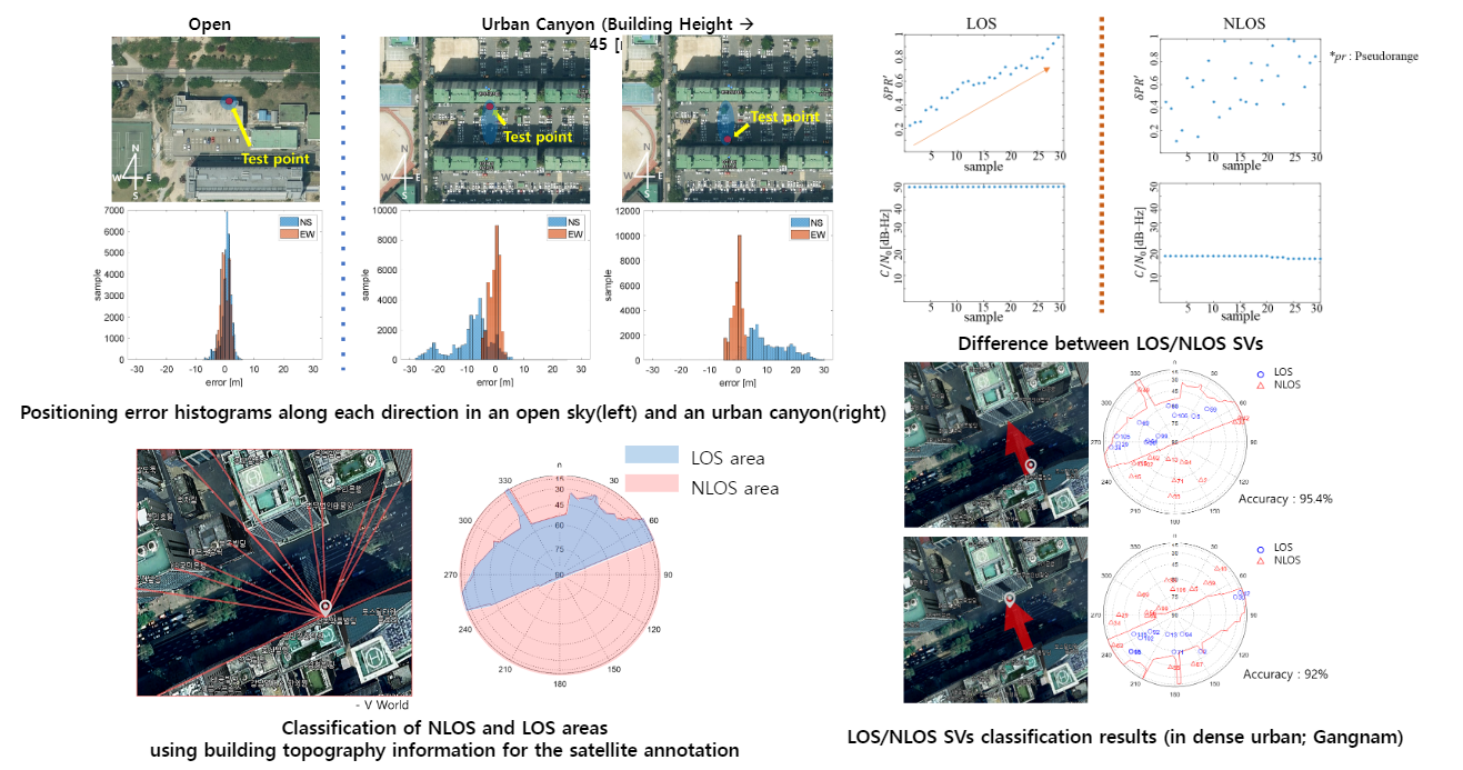
- 도시영역에서 측위 오차를 크게 유발시키는 NLOS 인공위성을 인공지능(RNN)을 사용하여 구분하는데 성공하였고(약 90%의 정확도), 실제 인공위성 수신기에 AVE lab이 개발한 기술을 적용하여 측위 오차를 50%까지 낮추었다.
차세대 GNSS 신호 변조 기법
AVE lab’s LPI waveform recognition system
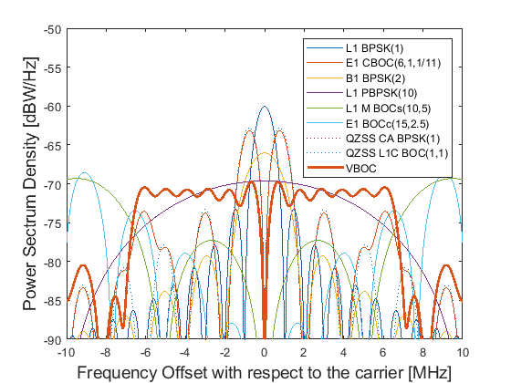
PSDs of VBOC and conventional GNSS modulations

ACF envelopes of VBOC and
conventional GNSS modulations
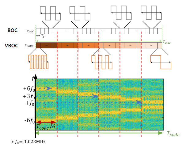
- 한국형 GPS (KPS) 신호를 목표로, 차세대 GNSS신호가 갖추어야 되는 GNSS 시스템간 낮은 간섭, 높은 거리 측정 정확도, 다중경로 및 노이즈 채널에 대한 강건성 등을 갖춘 변조 기법을 개발하였다.
- 기존 GNSS에서 사용하는 BOC 변조기법과 SFCW를 융합하여, 변조기법의 구조가 간단하면서 성능면에서 매우 우수한 변조기법이다.
셀룰러 핑거프린팅 기술
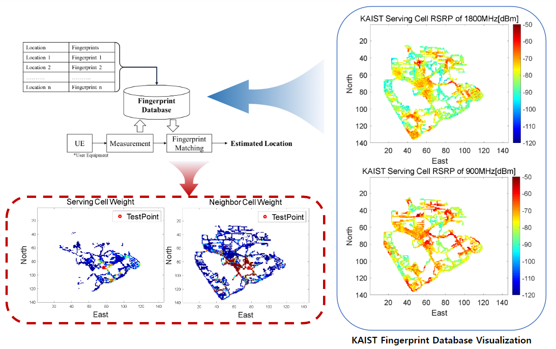
- 밀집된 도시 영역과 같이 GPS 측위오차가 크거나 측위가 불가능한 지역에서, 높은 정확도의 측위를 가능케하기 위해 AVE lab에서는 셀룰러 기지국의 신호 데이터 정보를 활용하여 셀룰러 핑거프린팅 기술을 개발하였다.
- 카이스트 본교(대전) 및 실제 도시 영역(종로; 광화문-인사동)에서 필드 테스트를 수행하였고, GPS 측위 없이 도시영역에서 오차 30m이하의 측위 성능을 달성하였다.
- 현재는 KT에서 AVE lab이 개발한 셀룰러 핑거프린팅 기술을 상용화하고 있다.

